The school applications portal is currently under maintenance in preparation for new school applications. You will not be able to access your account over the bank holiday weekend. We apologise for any inconvenience.
About the A259
The A259 is one of the key areas of the city identified for active travel improvements by our Local Cycling and Walking Infrastructure Plan (LCWIP). It’s also part of the National Cycle Network (NCN route 2). Currently, there is no separated cycle route west of Hove Lagoon to the city’s western boundary.
It’s a popular route for commuters, residents and visitors who enjoy cycling alongside our beautiful and vibrant seafront to local shops, businesses and attractions.
How the scheme is being funded
We were awarded £4.3 million of funding by Active Travel England to make improvements along the road to support active travel. £2.7 million has also been allocated from the council’s Local Transport Plan funding (spread over 3 years).
Details of the changes to the A259
Below you can find detailed information about different parts of the scheme and how they may affect you.
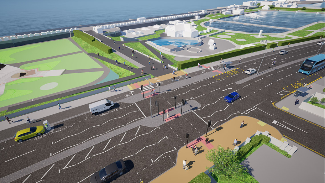
Removing a traffic lane between Fourth Avenue and Hove Street
One westbound traffic lane will be removed between Fourth Avenue and Hove Street to allow space for widened pavements, the cycle lane and parking and loading spaces.
The costs to remove the centre island to retain 2 lanes in each direction would be high and when traffic data and vehicle movements were analysed, it showed this option would not provide good value for money.
The highest hourly westbound traffic flow recorded in the past decade, within the project area, is 1,103 vehicles. Removing one westbound lane will still provide capacity of 1,620 vehicles per hour.
In addition, the inside lane between Fourth Avenue and Hove Street is less well used because 80% of vehicles continue forward in the lane they have been travelling in from West Street (where the vehicle lanes reduce from 2 to 1).
Parking for businesses and disabled people
In some locations the amount of parking will remain the same but moved next to the cycle lane (separated by a kerb). Overall we will be installing:
- an additional 12 disabled bays
- 8 more loading bays
- 10 new electric vehicle charging bays
Other parking changes
We've tried to retain the parking spaces along the length of the route and where we are making changes to the road layout. This has even enabled additional parking spaces to be found.
However, due to road width restrictions, we'll be removing some under-used parking along the south side of the A259 between Hove Lagoon and Boundary Road. We have managed to retain parking where it is most used along this stretch, outside businesses and near Hove Lagoon.
Facilitating deliveries to shops
Delivery vehicles servicing the parade of shops near the King Alfred Centre often double park preventing both vehicle lanes from being used.
This has been addressed in the new designs with the provision of 4 additional loading bays alongside the 2 already in place.
Loading bays have also been provided for the businesses in Hove Beach Park and nearer Boundary Road, where Ocean Sports and Pets Corner are located.
Improving the current cycle lane
Moving the cycle lane away from the Hove Beach Park entrances will make it much safer for pedestrians to move around and access these facilities.
Also, new national design standards for cycling were released in July 2020 which raises the standards for cycle lanes, including the use of protection to ensure cyclists are safe from vehicles on busy routes. The new cycle lane would provide a barrier away from pedestrians and motor vehicles.
Bus stops and changes to bus stop designs
Bus stops along the whole route have been reviewed and where appropriate, relocated to better suit user access to amenities, ensure they are properly spaced out and, in some cases, to allow the space for vehicles to overtake when a bus is stationary.
A bus stop bypass, also known as a floating bus stop or bus island, is a design where a cycle lane is routed behind the bus passenger boarding area to maintain separation from motor traffic. This design aims to improve safety by minimising conflicts between cyclists, buses and vehicles.
This scheme provides a flat, straight, wide and open stretch of road and provides good visibility for pedestrians using the bus stop and cyclists.
We’ll also be installing the following at the bus stop locations:
- zebra crossings across the cycle lane
- tactile paving at these crossing points
- raising the cycle lane at pedestrian crossing points
- islands to get on and off the bus
- other signage and markings to slow cyclists
Left turn ban into Hove Street South
Different options were explored and modelled for the Hove Street South junction. This option was the safest for cyclists and pedestrians to navigate while minimising congestion for other road users.
Our surveys found of the 8,500 to 12,000 vehicles which travel westbound at this junction a day, only around 200 turn left into Hove Street South.
Vehicles will still be able to access Hove Street South and the King Alfred Leisure Centre car park from the north and west.
Shared use section between Boundary Road Junction and Church Road Junction
Due to the space available, we're unable to safely install a separated cycle lane and retain the pavement and road widths required in this area. A widened, shared pedestrian and cycle space will be nearly double the current pavement width.
Surveys and monitoring have shown footfall is very low in this section.
Detailed plans
These plans are provided for information but are subject to change during construction.